Nara Prefecture extends far south of its compact historic city into the vast Kii Peninsula mountain range — one of Japan’s largest areas of wilderness, designated UNESCO World Heritage for its sacred mountain landscapes and ancient pilgrimage routes. The prefecture’s natural world ranges from a 1,300-year-old urban forest that has never been logged to a 30,000-tree cherry blossom landscape that has been celebrated in Japanese poetry since the 8th century. For nature travellers, the southern two-thirds of Nara Prefecture — largely unknown outside Japan — is extraordinary.
🌸 Mt. Yoshino — 30,000 Cherry Trees
Access: Kintetsu Yoshino Line to Yoshino Station (approx. 90 min from Osaka Abeno-bashi, 90 min from Kintetsu Nara Station via Kashihara-jingumae), then ropeway or 20 min walk to lower cherry zone Best timing: Late March to mid-April; peak early April (varies by year) Accommodation: Book December–January for April stays — fills completely months ahead
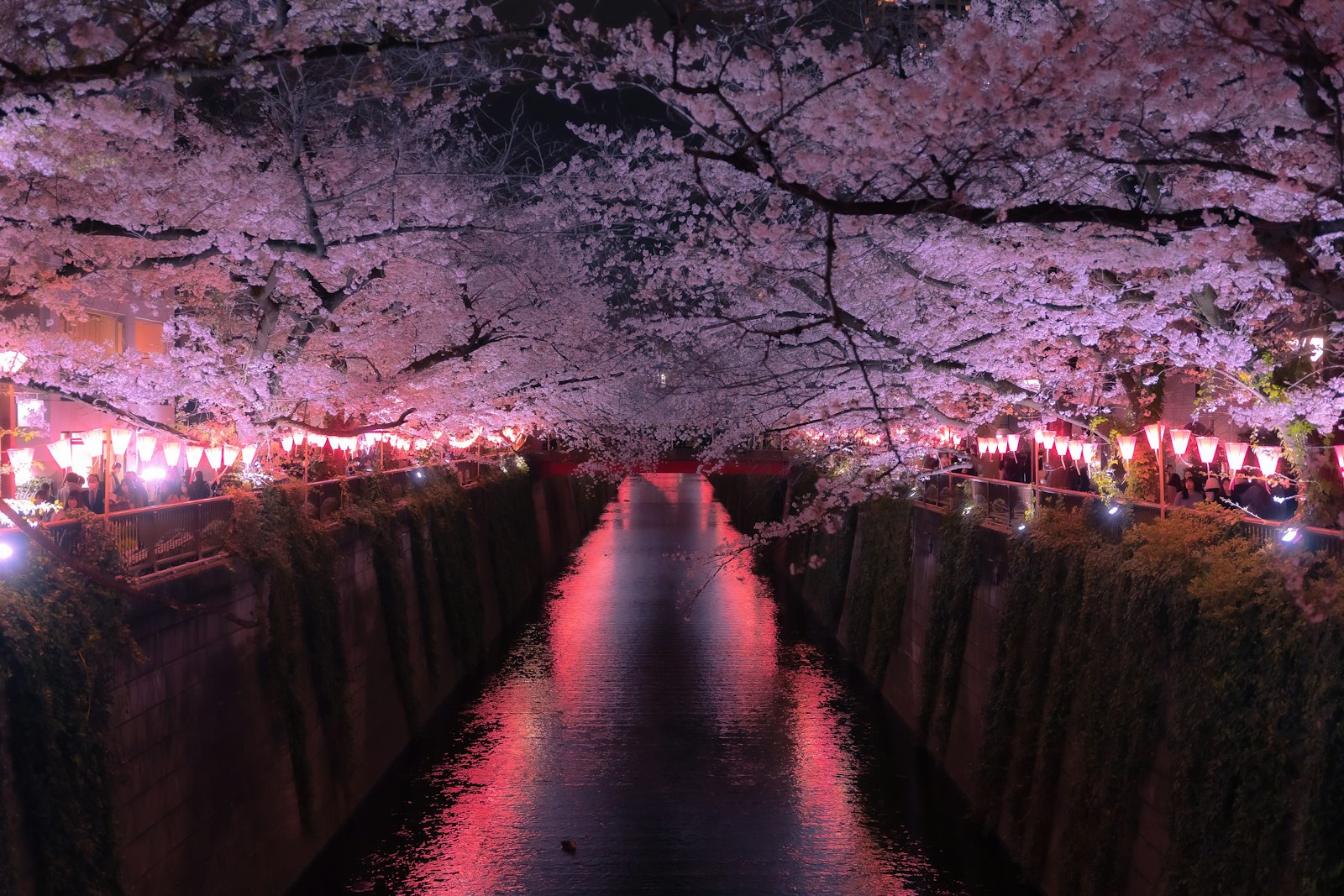
Yoshino is Japan’s most famous cherry blossom location. Approximately 30,000 cherry trees — almost entirely Yoshino cherry (Prunus × yedoensis) — are planted across Mt. Yoshino’s slopes in four distinct bands designated as Shimo-senbon (lower), Naka-senbon (middle), Kami-senbon (upper), and Oku-senbon (inner). The trees bloom progressively from lower to upper elevations over approximately two weeks, creating a continuously shifting spectacle.
The four bands:
- Shimo-senbon (lower): Most accessible, most crowded, blooms first. The approach from the ropeway to Yoshino’s main shopping street passes through this band — beautiful but packed with day visitors.
- Naka-senbon (middle): The main viewing area around Chikurin-in temple and Yoshimizu Shrine. The view from the Yoshimizu Shrine compound down over the lower mountain — a sea of pale pink against green cedar — is the classic Yoshino image. This band is also crowded during peak bloom.
- Kami-senbon (upper): A 30–40 minute walk uphill from the main street, past Kinpusen-ji temple. The crowds thin substantially here. The trees are older and larger, creating a more canopy-like effect.
- Oku-senbon (inner): A further 2km beyond the upper area, accessible by taxi or 1-hour walk. This section — the deepest mountain forest, highest elevation, last to bloom — is where Yoshino reveals itself most fully. The scale and silence here are unlike the lower areas. Many visitors never make it; those who do consider it the finest cherry blossom experience in Japan.
Insider advice: Staying overnight on Mt. Yoshino transforms the experience. After the last day-trip ropeway departure (around 17:00), the village empties. Morning light through the cherry blossoms before 7:00am, with mist rising from the mountain, is available only to those who sleep on the mountain. Yoshino’s traditional inns and ryokan range from basic minshuku to refined establishments — but all fill months ahead for April stays.
🌲 Kasugayama Primeval Forest — UNESCO Sacred Grove
Access: Walk northeast from Kasuga Taisha Honden (main shrine) — the forest begins immediately behind the shrine Admission: Free (trail from shrine freely accessible) | Open: Daylight hours
The Kasugayama Primeval Forest has been protected as sacred land for the Kasuga Taisha shrine since 768 AD — never logged, never cleared, never cultivated for 1,250 years. The result is a mature secondary forest of Japanese cedar (sugi), hinoki cypress, and broad-leaved species that represents what the Nara basin’s original forest cover would have looked like before human settlement.
The forest covers approximately 250 hectares on the hills directly behind Kasuga Taisha and is listed as part of the Historic Monuments of Ancient Nara UNESCO World Heritage Site. A network of designated trails runs through the forest, accessible from the shrine precinct. The main trail continues to Kasugayama peak and connects to the wider Yamato Highlands trail system.
What makes this forest distinctive: The complete absence of human intervention for 12+ centuries has produced a forest of unusual density and character. The understorey — moss, ferns, and shade-tolerant shrubs — is undisturbed. Deer move through silently. The atmosphere shifts noticeably as you enter: temperature drops, sound dampens, the light becomes filtered and green. This is one of the few places in central Japan where you can experience what old-growth forest feels like.
The trail: From Kasuga Taisha Honden (main shrine), follow the signs for Kasugayama jinja or the nature trail northeast. The path climbs gently and is well-marked. A 45-minute circuit returns to the shrine precinct without retracing steps.
💧 Mitarai Gorge — Emerald Pools & Suspension Bridges
Access: Bus from Shimoichi-guchi Station (Kintetsu Yoshino Line) — approximately 40 min from the station. Or combine with a Dorogawa Onsen stay (the gorge is partway between Shimoichi-guchi and Dorogawa). Best season: Summer (river swimming, emerald water) and autumn (intense foliage) Trail: 8km return, relatively flat, 2–3 hours
The Mitarai Gorge (みたらい渓谷) follows the Mitarai River through a narrow stone gorge in the Yoshino foothills — a trail of suspension bridges, mossy rock formations, waterfalls, and crystalline pools whose water turns a striking emerald-green in the right light conditions. This is not wilderness hiking — the trail is well-maintained with handrails and viewing platforms — but the gorge scenery is genuinely spectacular.
Highlights along the trail:
- Mitarai Waterfall: Directly accessible from the trailhead — a 30-metre cascade into a pool that’s popular for paddling and photography
- Suspension bridges: Three bridges cross the gorge at different heights; the lowest is above the water surface, the highest gives a full view down the rock corridor
- Midway pools: The middle section of the trail passes through the gorge’s narrowest section, where the river has carved smooth stone channels and the water colour is most intense
- Autumn foliage: The gorge’s combination of overhanging maple trees and rushing water makes it one of Nara’s finest autumn viewing spots — late October to mid-November
🏔️ Odaigahara Plateau — Cloud Forest & Alpine Walking
Access: Bus from Kashihara-jingumae or Yamato-Yagi Station (approx. 3 hours — infrequent service, check timetable carefully); or rental car/taxi from Kashihara area Elevation: 1,695m | Best season: Late June to October (snowbound in winter) Trail: Multiple options from 2 hours to full-day circuits
The Odaigahara Plateau is one of Japan’s wettest places — receiving over 4,000mm of annual rainfall — which has produced a remarkable montane cloud forest of moss-covered conifers, dwarf bamboo, and Sitka-like conifers permanently draped in mist. The plateau sits at the intersection of the Yoshino and Kumano mountain ranges and forms part of the UNESCO Yoshino-Kumano World Heritage Zone.
The main trail from the Odaigahara Visitor Centre at the plateau’s summit follows the ridge through the Nishi-no-Take (western peak) circuit — approximately 4 hours — with views in clear weather extending across the Kii Peninsula to the Pacific Ocean. The Shishigase Waterfall (accessible as a 2-hour return hike from the car park) drops 30 metres into a boulder-strewn valley floor.
The atmosphere: Even in August, Odaigahara is cool (15–18°C) and frequently misty. The cloud forest — ancient moss-covered trees, gnarled roots, the sound of dripping water — has an eerie, primeval quality. It feels nothing like the rest of Nara Prefecture.
🚣 Dorokyo Gorge — River Cruise Through Mountain Wilderness
Access: Bus from Totsugawa area or from Shingu (Wakayama) — requires planning; Shingu is accessible by the Kinki Nippon Tourist special cruises or by bus from JR Shingu Station (Nanki Shirahama route) Duration: 3-hour boat tour (downstream) | Season: April–November
The Dorokyo Gorge on the Kitayama River in southern Nara/northern Mie Prefecture is one of Japan’s most dramatic river gorges: sheer rock walls rising 100 metres from the water, ancient cedar forests clinging to vertical cliffs, and a river navigated only by flat-bottomed wooden boats (yakatabune). The 3-hour downstream cruise from the Dorokyo boat terminal takes you through the full length of the gorge, with stops at dramatic viewpoints.
This is remote, serious wilderness. The canyon was largely inaccessible by land until recent road construction, and the river is still the most atmospheric way to experience it. Combined with the Totsugawa onsen area (a further upstream, same river system), Dorokyo forms the centrepiece of a 2-night southern Nara itinerary.
🌾 Soni Highland — Autumn Pampas Grass
Access: Bus from Haibara Station (Kintetsu Osaka Line, 50 min from Yamato-Yagi) — check bus timetable, services limited Best season: Late September to mid-October Elevation: Approximately 900m
Soni Highland (曽爾高原) is Nara’s most photogenic autumn landscape: a broad mountain plateau covered with ススキ (susuki) pampas grass that turns gold and silver in late September, swaying in the highland wind against a backdrop of dramatic rocky peaks. The plateau is relatively unknown outside Japan and essentially empty of overseas visitors.
The viewing is best at sunset, when backlighting turns the grass heads to glowing silver. The moderate uphill walk to the main viewing area takes 20 minutes from the bus stop. A larger circuit around the plateau and over Kameyama peak (849m) takes 2–3 hours and passes through old-growth woodland.
🌋 Mt. Wakakusa — City-Accessible Hill with Annual Burning
Access: 30 min walk from Todai-ji / Kasuga Taisha; or short walk from the edge of Nara Park Admission: ¥150 | Open: Late January to November (closed in winter outside burning season) Height: 342m, approximately 45 min to summit
Mt. Wakakusa is Nara Park’s distinctive open hillside — a grass-covered ridge that gives the park its visual depth when viewed from Kofuku-ji’s pagoda. The 45-minute climb to the summit offers a panoramic view of the Yamato Plain, Nara city, and, on clear days, the mountains of Osaka Prefecture. Deer graze freely on the slopes.
Every January, the entire hillside is ceremonially burned (Wakakusayama Yaki) — one of Japan’s most spectacular fire events, visible from much of Nara city. The burning happens on a Saturday in mid-January; the flames at night are vivid from the park below. See the events guide for details.


